ARLINGTON — What has been a common shortcut for fisherman since the dike was built in the 1930s is now open to general explorers.
The “new” Eagle Trail from Haller Park west to the Dike Road is the result of a partnership between the city of Arlington’s natural resource manager, Bill Blake, and Eagle Scout Joel Larson, with encouragement from Larson’s grandma, Mayor Margaret Larson.
“It was a fun project,” Mayor Larson said.
“Joel is lucky to have a father who was a builder. He got help from his Aunt Mary, too, who designed the lettering on the sign and got posts from her work, the former Baxter pole company. He even bought donuts,” Larson said, adding the Eagle Scout project is all about learning to manage a crew.
The trail will be opened officially Feb. 7 as part of the Eagle Festival. (For more information on the tribute to Stillaguamish Valley eagles, see page A6.)
The short trail contributes toward the city’s long-range vision of having an extensive riverfront park open to the public.
“There will be more riverfront access when the Graafstra farm opens to the public as a park,” Blake said.
The trail doesn’t look much like a trail yet, but it will with more use.
The public is invited to pass under the gate at Haller Park, then proceed on the gravel driveway under the new SR 9 Haller Bridge to the city-owned Round House, on property which was acquired by the city for future use in developing a treatment system for the city’s waste water.
The round house is being used for some water department meetings, Blake said.
Keep walking past the house and the barn, which was damaged by the recent snow, and along the dike at the edge of the river. Before long there’s a big hole in the dike — the breach from the latest flood in early January. Explorers on the new trail can see the power of the river once it finds a weak spot and notice the pile of gravel that was strewn across the field by the force of the river.
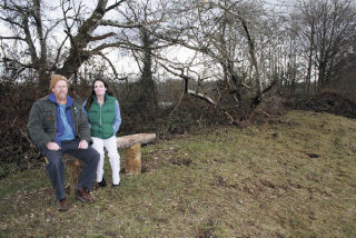
Continue on down the river bank to find two benches, before reaching the Dike Road, where another big hole was left under the ecology blocks used to prevent vehicles from entering the service road into the field.
The service road provides access to the river bar for walkers.
Two of the ecology blocks were carried across the road and left stranded in the grove of young cedar trees planted by Dan Grewe.
The field at the northwest corner of the intersection of SR 9 and SR 530 is owned by the city but is inside the jurisdiction of the county, Blake explained. The city is currently in the process of applying for permits to build wetlands that will be the final destination of the city’s waste water after it is processed through the newly upgraded wastewater treatment plant. The contract for the upgrade on the treatment plant is currently being reviewed by the city.
“We will probably construct the wetland in 2010,” Blake said. “We have to get shoreline permits in place before moving forward.”
The project also includes a future osprey home. Blake got assistance from two people from Oso which features a long “telephone” post with a platform attached on top to be installed after permits are acquired.
“Kevin Van Arnam and Bruce Blacker helped me get all the parts together,” Blake said.
The constructed wetlands will offer trails for people to wander on, as they meander between pools and ponds with cattails, a classic sign of wetlands.
“We plan to harvest the cattails and sell to florists. I see them for sale all over,” said Blake before returning to City Hall to meet with FEMA officials and show them the damage from the recent flood.
“It could be very profitable,” Blake said.