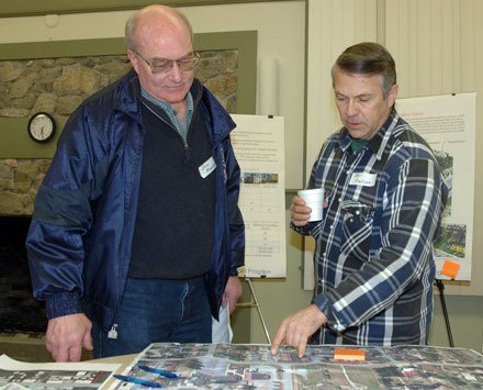
ARLINGTON — Citizens expressed concerns over the West Arlington subarea draft form-based code and Transfer of Development Rights program during a meeting with city of Arlington officials and representatives of Makers Architecture and Urban Design on Wednesday, Jan. 11.
The city of Arlington had adopted the West Arlington subarea plan on Feb. 7 of last year. It’s a long-range plan intended to guide growth and development in Smokey Point, West Bluff, Island Crossing and other western portions of Arlington, and the form-based code is the primary tool in implementing this plan.
Form-based code regulates development to achieve specific urban forms, in part by focusing on land use, but mostly by designating as “acceptable” and “unacceptable” certain physical forms and masses of buildings in relation to one another, as well as scales and types of streets and blocks.
City of Arlington Community Development Director David Kuhl and Natural Resources Manager Bill Blake were joined by Bob Bengford of Makers Architecture and Urban Design in outlining a proposal to provide a mixture of housing types and the opportunity for mixed-use development in the highest population areas of Smokey Point, to serve as its pedestrian-oriented neighborhood center.
Under the TDR portion of the program, the West Arlington subarea and Breckhus-Beach would serve as “receiving” areas for development rights from the Stillaguamish Valley, to provide an incentive for developers to concentrate urban density in areas without wetlands, while foregoing development in the floodplain to help protect agricultural resources for those land owners who wish to participate.
“This is all about new development,” Bengford said, preemptively answering one question that area residents Linda Wagner and Bev Emery had planned to ask. “If you have a building that’s already there, you don’t have to worry about it, but if you’re building a new residence or community building, it would need to meet these standards. Larger buildings would be subject to a review process.”
The TDR incentives would allow residential uses east of Smokey Point Boulevard just north of 188th Street NE, and just south of 172nd Street NE, as well as allowing extra density along Smokey Point Boulevard between 188th and 172nd streets. The Island Crossing triangle of Smokey Point Boulevard, I-5 and Pioneer Highway would have a TDR incentive for extra building height for hotels, from 35-65 feet.
“East of Walmart is an empty area that’s a huge opportunity for the city,” Bengford said. “We can work with property owners to mix retail and residential, and integrate a pedestrian-oriented center with trails, because that’s too much land for it all to be commercial.”
After Bengford explained how the Knudson property could be used as the site for a park within the higher-density development along Smokey Point Boulevard, Neil Knudson raised concerns over the ability of larger fire vehicles to navigate the streets between such tall and densely situated buildings, whose multiple floors he also predicted would pose a challenge for aging Baby Boomers not looking to climb flights of stairs. Bengford assured him that the fire district would be checking the buildings for code, and anticipated that the buildings would include sufficient elevators and ground-floor living units.
In response to objections about alfalfa farming land being lost to the TDR program in the urban growth areas, Bengford noted that participation is by property owners’ choice and the land is already zoned for commercial use
When asked how integrated the streets from these developments would be with neighboring Marysville, Kuhl agreed that one of the city of Arlington’s goals is to foster “good circulation through the whole area,” to which city of Arlington Associate Planner Todd Hall added that both Arlington and Marysville are exploring more north-south routes of transportation.
The Jan. 11 meeting was the second public workshop on this issue, and will be followed by two subcommittee meetings, the second of which is tentatively set for this spring, just prior to the two adoption process meetings in the spring and summer of this year. City of Arlington officials aim to incorporate input that they receive from the community into the revised form-based code.