ARLINGTON – People interested in learning about crime in Arlington and in their own neighborhood now have the data at their fingertips thanks to a new web-based program.
Arlington police this week unveiled a flexible, innovative new crime mapping system available to city residents and business owners.
Snohomish County police agencies, in partnership with dispatch centers SNOPAC and SNOCOM, have been rolling out the new system. It comes with no added cost, since the data comes via the regional police records system, New World, used by county law enforcement.
Arlington Police Chief Jonathan Ventura demonstrated the system at the City Council work session Monday.
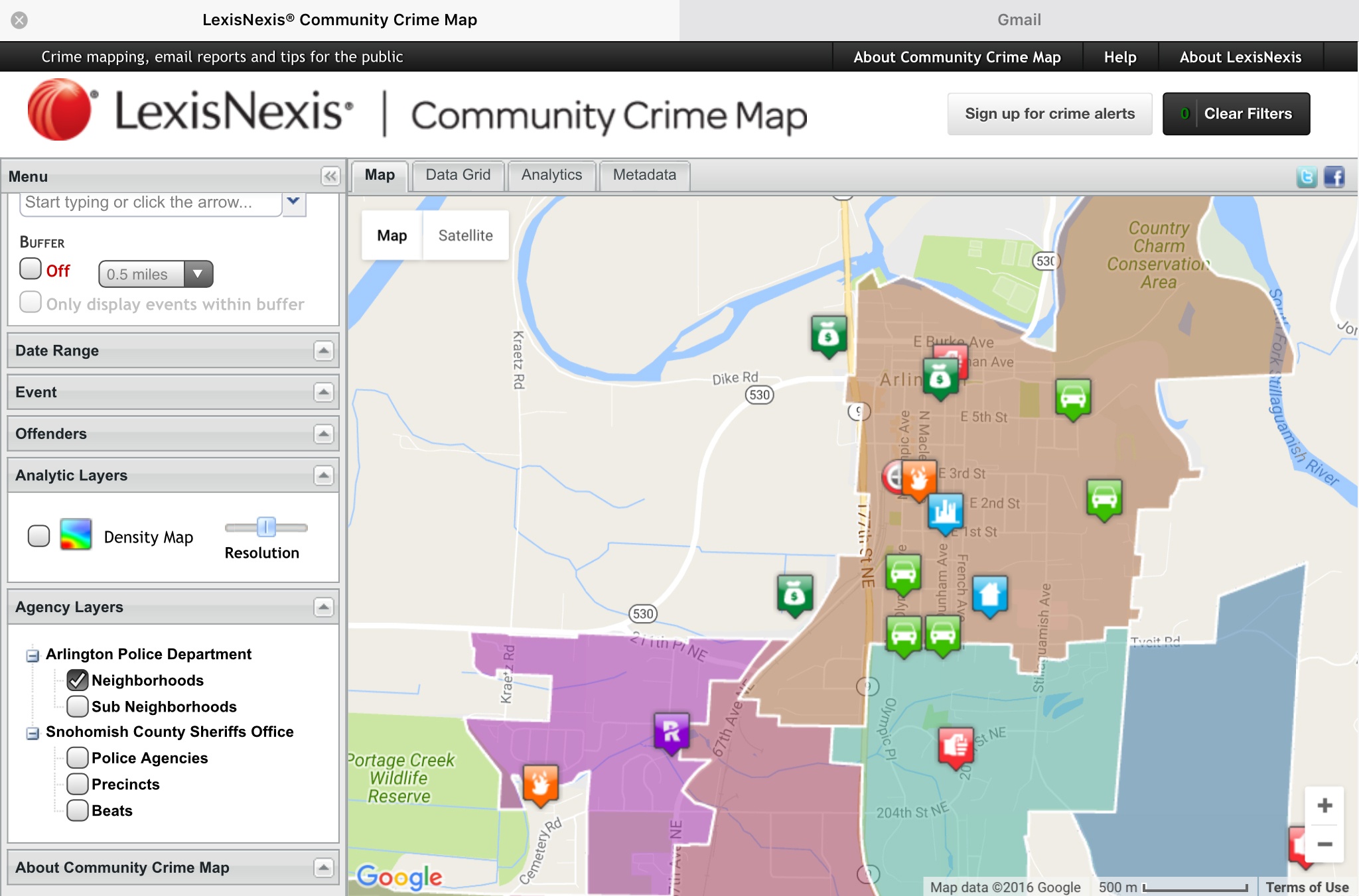
With the new system, Arlington residents and business owners can view data from police reports. Just type in your address, or another address, and colored icons different for each type of crime will appear on the map. Click on the icon for a crime incident, and it will expand to show more information about that crime. It will give the incident report number, crime, date, time, general location and other information. To protect privacy, the actual incident location is offset on the display.
A range of violent, property and quality-of-life crimes are viewable on the map. The map defaults to show crimes for the previous 30 days, but residents can change the time period if they want.
Ventura said two types of crime are not viewable on the map in order to protect the privacy of victims: domestic violence and child sexual assault cases.
One of the features that Ventura said the public will like is the ability to cross-reference crimes in their neighborhood with other neighborhoods. Arlington and Everett are the only communities in the county so far that have that ability.
Ventura said at times residents have mentioned a high rate of a particular crime occurring in their neighborhood. With the new map system, a resident can put their own perception to the test by comparing their neighborhood with others. They may find that the problem is more prevalent across a wider area.
The crime mapping system has several other features.
Residents and business owners can sign up for email alerts about crimes that have occurred within a certain distance from their home, workplace or school. Ventura added that with several crime and community pages on social media, that information can be posted to those sites as well.
The system can also display “hot zones,” showing concentrations of crimes–for example car prowls.
Another option is a button that shares with the public where sex offenders are living; click on the icon to bring up a photo and additional conviction information.
Also, in the event of a crime spree where police need the public’s help, police can add a hyperlink on a crime pop-up so that people can report immediately if they have information that would help catch a criminal.
While the public has plenty of ways to explore the crime data, the system includes even more advanced analytical tools for police. It’s almost like having a crime analyst on the payroll. For example, officers have more flexibility in identifying hot spots, detecting crime patterns and forecasting trends.
Where the public gets data from the crime report itself – updated by the department every 24 hours – police get the data as it’s entered from 911, which includes specific addresses.
Ventura said crime mapping is a great tool designed to enable a better-informed, more engaged public to partner with police, help reduce crime and improve public safety.The LexisNexis Risk Solutions system and can be viewed at communitycrimemap.com.